York River Watershed
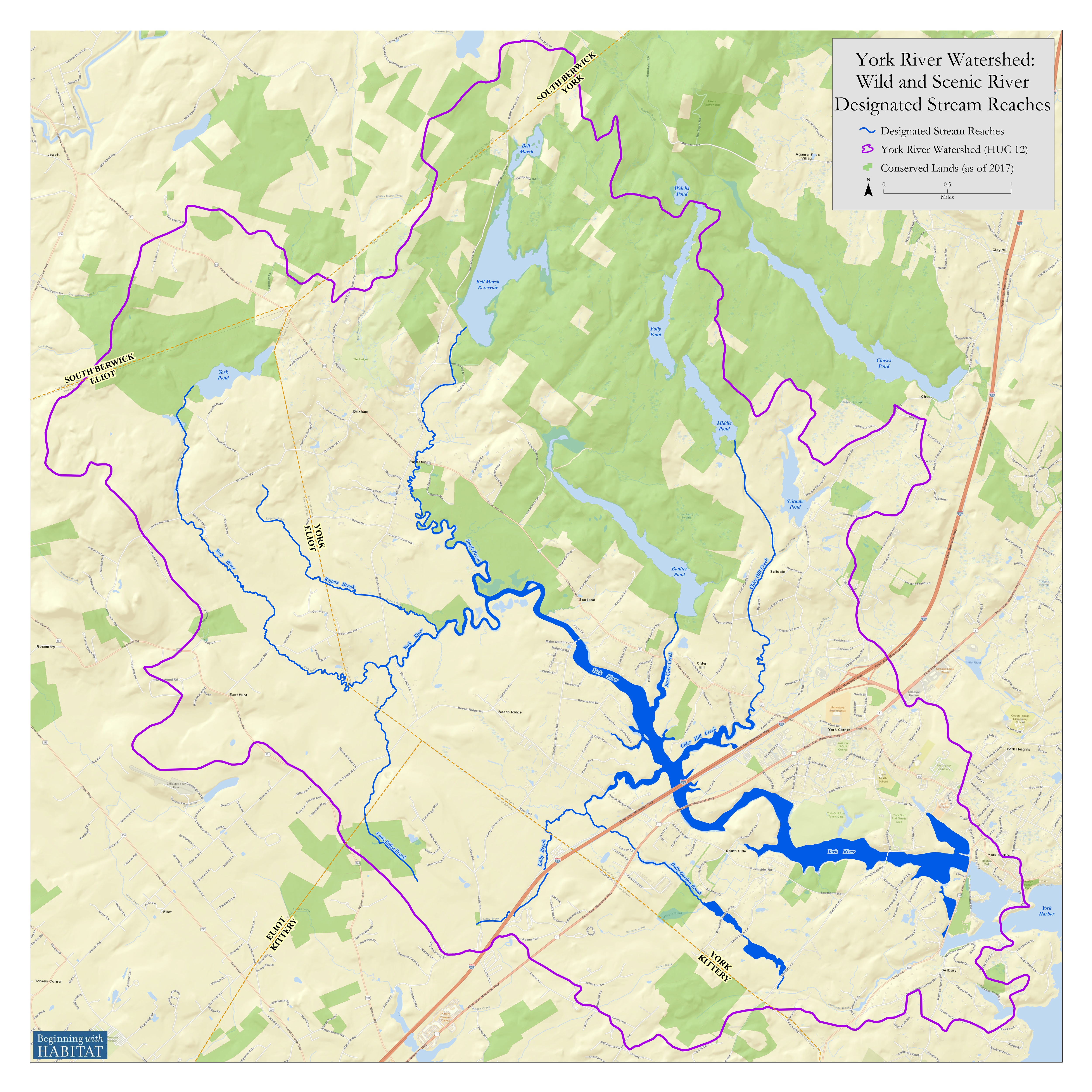
The York River watershed covers 33 square miles in parts of South Berwick, Eliot, Kittery, and York.
The Watershed
A watershed is the land area from which water flows to form the network of tributaries and brooks that contribute to a river system. While the York River is only 13 miles long, there are over 100 miles of streams in the watershed that flow to the river.
The River
The York River is a tidal river, with smaller unnavigable freshwater tributaries feeding into a relatively large tidal basin. Tidal fluctuation can be more than 10 feet. The York River has its headwaters in South Berwick and flows to the Gulf of Maine.

Watershed Map
This map that highlights the York River and major tributaries that were designated into the National Wild and Scenic Rivers System (darker blue) also shows the watershed boundary, roads, town boundaries, and conservation lands.
The watershed includes large areas of undeveloped forest land and open space, including over 6,000 acres of conservation and water supply lands representing about 28% of the total area. Within the watershed, the Kittery Water District owns four man-made ponds and dams located in the Town of York. These ponds – Boulter Pond, Folly Pond, Middle Pond and Bell Marsh Reservoir – provide water to the residents of Kittery, the Portsmouth Naval Shipyard, and portions of York and Eliot.
History and Habitats
The York River watershed includes many exemplary resources and values: cultural and historic resources; biodiversity and natural resources; recreational and scenic values; and water quality and watershed services. The York River Watershed Stewardship Plan identifies resources that are most valued by the community and includes strategies and actions to protect or enhance those resources. The river’s many unique, rare, and exemplary values, plus its clean water, made it eligible for designation into the National Wild and Scenic Rivers System – and are worthy of protection for the benefit of current and future generations.

HIGHLIGHTS
Cultural & Historic Resources
Working waterfronts involving fishing piers, wharves, and town docks; the first of its kind dock conservation easement to maintain commercial fishing operations and access occurred on the York River’
Historic dams and mill sites
Nationally and locally significant historic districts, sites, buildings, structures, and landmarks (e.g., National Register of Historic Places district and properties, local historic districts, privately protected historic resources)
Connections to nationally significant events and persons (e.g., Samuel Clemens, May Sarton, Captain John Smith, Rufus McIntire, Thomas Morton, etc.)
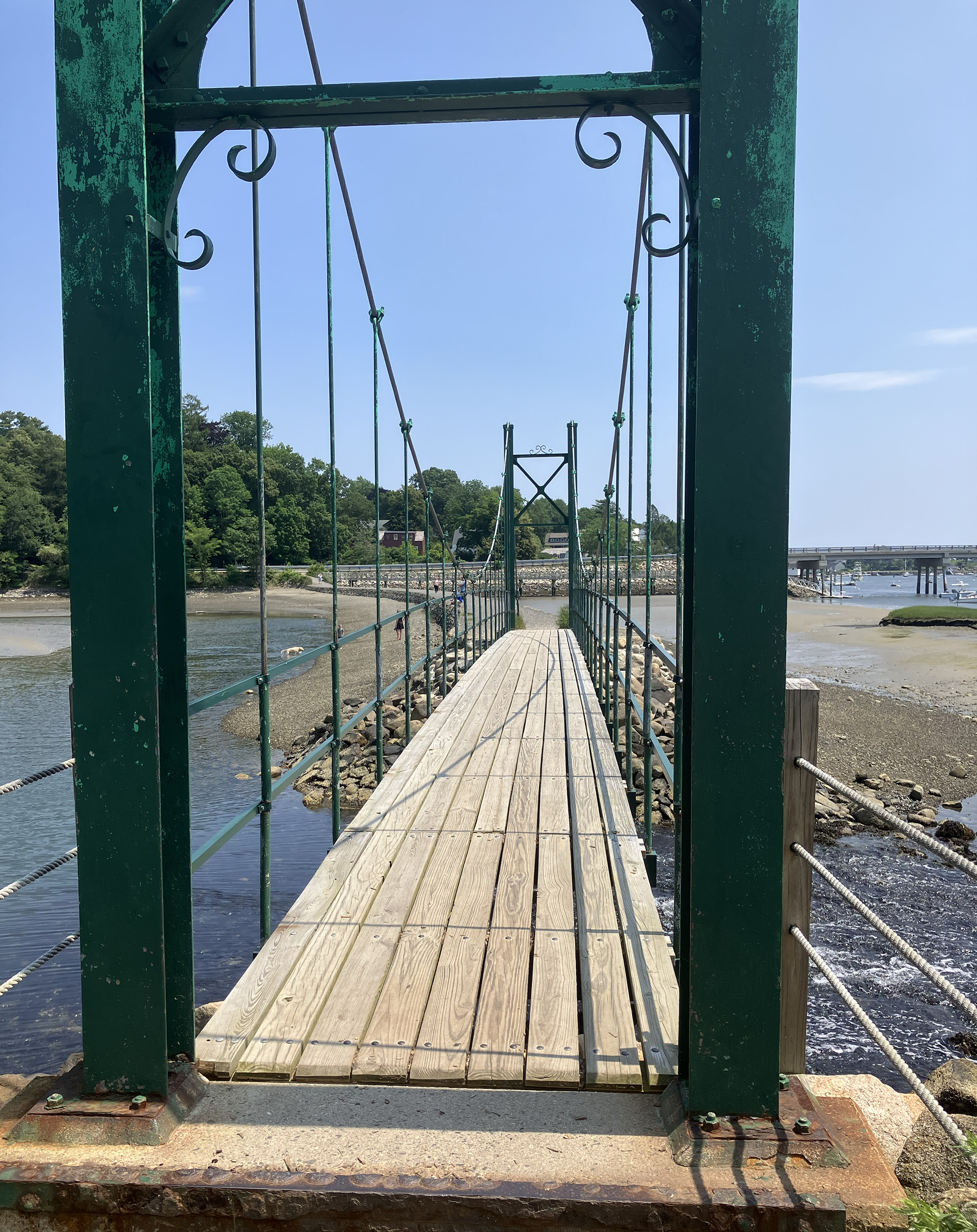
Nationally significant bridges (e.g., Sewall’s Bridge, thermoplastic bridge, Wiggly Bridge)
Archaeological sites that yield information important to history or prehistory (e.g., early Euro-historic settlement sites, Punkintown settlement, shipwrecks, terrestrial and submerged Native American archaeological sites, maritime industrial sites such as shipbuilding, brick-making, fishing, river and tidal milling sites)
Active historic community, artistic inspiration, and other historic river-related activities (e.g., Old York Historical Society, tourism)

HIGHLIGHTS
Natural Resources & Biodiversity
The York River watershed, much of which is characterized by large undeveloped forest areas and healthy stream buffers, supports diverse and rare species and exemplary natural habitats. The estuary is one of the least disturbed marsh-estuarine ecosystems and possibly the most ecologically diverse coastal drainage area for its size in the Gulf of Maine. Some examples of the exceptional natural resources and biodiversity in the watershed include:
- Approximately 500 acres of salt marsh habitat, representing 10% of salt marsh in York County and the largest intact coastal wetland area in southern Maine; these coastal wetlands provide habitat to many species, store large amounts of carbon, and protect adjacent areas from flooding and erosion
- Productive tidal flats/mud flats
- Watershed includes part of the largest intact coastal forest between Acadia and New Jersey Pinelands
- Exceptional diversity and wide array of special habitats created by biome transition of northern and southern forests
- Greatest concentration of threatened and endangered species of any Maine region (e.g., New England Cottontail, ringed boghaunter dragonfly, saltmarsh sharp-tailed sparrow, Blanding’s and other turtles, rare plants)
- Diverse fish species and diverse array of supporting habitats, including spawning habitat
- Protected headwaters for York River and many major tributaries, healthy riparian corridors, and intact stream buffers
- Species and habitat diversity makes the watershed an important area for numerous conservation initiatives
Presentations and Information
Presentations, recordings, and reports on topics of interest to the Stewardship Committee are noted below.
- Learn about climate resiliency and adaptation measures: York River and Climate Change poster
- The Climate Ready Coast project (led by Wells Reserve and Southern Maine Planning and Development Commission) culminated with development of the Regional Coastal Resilience Plan that highlights climate vulnerabilities and adaptation strategies at ~50 sites across 10 southern Maine coastal towns, including 3 York River sites: Upper York River and Smelt Brook; York River I-95 & Route 1 crossings; York River/Harbor area
- Summary and link to the recording of a panel discussion on “Maine’s Saltwater Wetlands Under Pressure” hosted by Wells Reserve and the Maine Monitor, 3/27/24
- Water Quality Management and Protection for Wild and Scenic Rivers – A technical report of the Interagency Wild and Scenic Rivers Coordinating Council, February 2024
Story maps developed during the York River Wild and Scenic Study:
- York River Watershed Stewardship Plan story map, developed by Wells NERR in 2018
- York River watershed build out study story map, developed by Southern Maine Planning and Development Commission and Spatial Alternatives, Inc. in 2018
- Infrastructure and stream barriers story map, developed by Wells NERR in 2017
